
Trace an Eagle Pass Street by Address
Ownership is the clearest public starting point for an Eagle Pass street directory search. The Maverick County Appraisal District property search can connect an address to its current appraisal account, owner, situs address, legal description, and deed-history summary. A situs address is the parcel's physical location. It does not identify every person who may live there. The street trail becomes more reliable when the appraisal account is paired with the legal description and then checked in the county clerk's recorded instruments.
- Enter the house number and street name in the CAD search. If the entry fails, follow CAD's own instruction to try the street name without its prefix, suffix, or unit number.
- Save the Property ID, Geographic ID, owner name, situs, tax year, subdivision, and lot, block, or tract description. These identifiers hold steady better than a formatted address.
- Use the legal description or latest deed row to search the Maverick County Clerk land index. Confirm the recorded instrument before treating the CAD summary as title evidence.
- Compare the parcel with its recorded plat and city planning maps. This establishes lot and street context, but a map line alone does not prove a legal boundary.
- For voter information, use the individual state portal only for its intended status check or make the formal voter-file request described by Texas law. Do not turn an address search into a public roster.
Each record answers a different question. CAD is a current appraisal view, a deed is a recorded transfer, and a voter file has statutory access limits. That is why a careful street-by-street search keeps dates with each result.
Search Eagle Pass Streets in CAD
The CAD form has both owner and advanced tabs. Its address route accepts Street Number and Street Name, while the advanced fields can narrow a result by Property ID, Geographic ID, Owner ID, subdivision, neighborhood, abstract, condominium, or mobile-home park. CAD specifically says its Street Name search should omit prefixes, suffixes, and unit numbers. That small instruction matters on a long Eagle Pass street and is the local search quirk worth trying before deciding that a parcel is missing.
| CAD field | Use on an Eagle Pass street | Format or limit |
|---|---|---|
| Owner Name | Find all accounts under a known owner | CAD suggests last name first, or one name component |
| Street Number and Street Name | Locate a situs or collect one street's parcel accounts | Street Name omits prefix, suffix, and unit |
| Property ID, Owner ID, Geographic ID | Carry the parcel into deed, plat, and later-year work | Optional stable identifiers |
| Subdivision or Neighborhood | Separate similar addresses or group lots | Search-list controls are available |
| Property Type and Tax Year | Refine an appraisal search | Optional dropdowns; live options can change |
Record the portal spelling as well as the postal spelling. CAD does not document a bulk street export or result-pagination behavior in the inspected form. For a full Eagle Pass address study, retain each returned account manually, sort by situs number, and distinguish accounts by Geographic ID and legal description rather than owner name alone.
Note: CAD labels legal descriptions and acreage as appraisal research information, so confirm both against the custodian's recorded documents before relying on them.
Read Eagle Pass Address Fields Carefully
A CAD result can show more than one address, and the difference is important. The situs is the physical parcel. The mailing address is where tax correspondence goes. It may be a post-office box, an agent, a company address, an out-of-town address, or a former residence. A homestead exemption can be an owner-occupancy clue, but CAD warns that not all exemptions display online for privacy. Neither a mailing field nor an exemption should be presented as proof of who currently lives at the situs.
- Parcel
- A tract or lot treated as one property account for appraisal and tax purposes.
- Situs address
- The physical location of the parcel, distinct from an owner's tax mailing address.
- Plat
- A recorded map that lays out a subdivision, lots, blocks, streets, rights-of-way, or easements.
- Criss-cross directory
- An address-first directory that can point to an occupant, then back to an alphabetical name entry. No Eagle Pass run has been verified.
Keep the legal description with the street number. In Maverick County, the description may use a subdivision with lot and block labels or a tract and acreage. It remains useful when a street number changes, a rural tract has no conventional number, or an Eagle Pass postal label reaches outside the city line.
Place Eagle Pass Parcels on a Plat
For a street segment, a recorded plat is the bridge between nearby and adjoining. Start with the target account's subdivision and lot or block, then compare the neighboring legal descriptions and Geographic IDs in CAD. The City of Eagle Pass planning maps page links zoning, city-limits, flood-hazard, thoroughfare, and historic-preservation maps. Those layers offer context for an Eagle Pass street, especially where a postal address and municipal jurisdiction differ.
No official Maverick County parcel viewer with confirmed owner popups, click-adjacent controls, buffer tools, or measuring mechanics was found in the research. The city zoning map is not a cadastral ownership viewer. Verify an actual shared boundary with the recorded plat and county-clerk deed, not a visual map line. This preserves the difference between a map neighborhood and a legal parcel relationship.
Follow Eagle Pass Deed Chains
Once CAD supplies a legal description, search TexasFile's Maverick County Clerk records search by name, instrument number, volume and page, date range, or legal fields such as subdivision, lot, block, tract, survey, and abstract. The result grid identifies the recording date, type, grantor, grantee, book or page number, and legal description. A grantor transfers an interest; a grantee receives it. Read those roles in the deed itself before drawing a conclusion about a household.
The Maverick County deed-index interface is shown in this authorized TexasFile source.
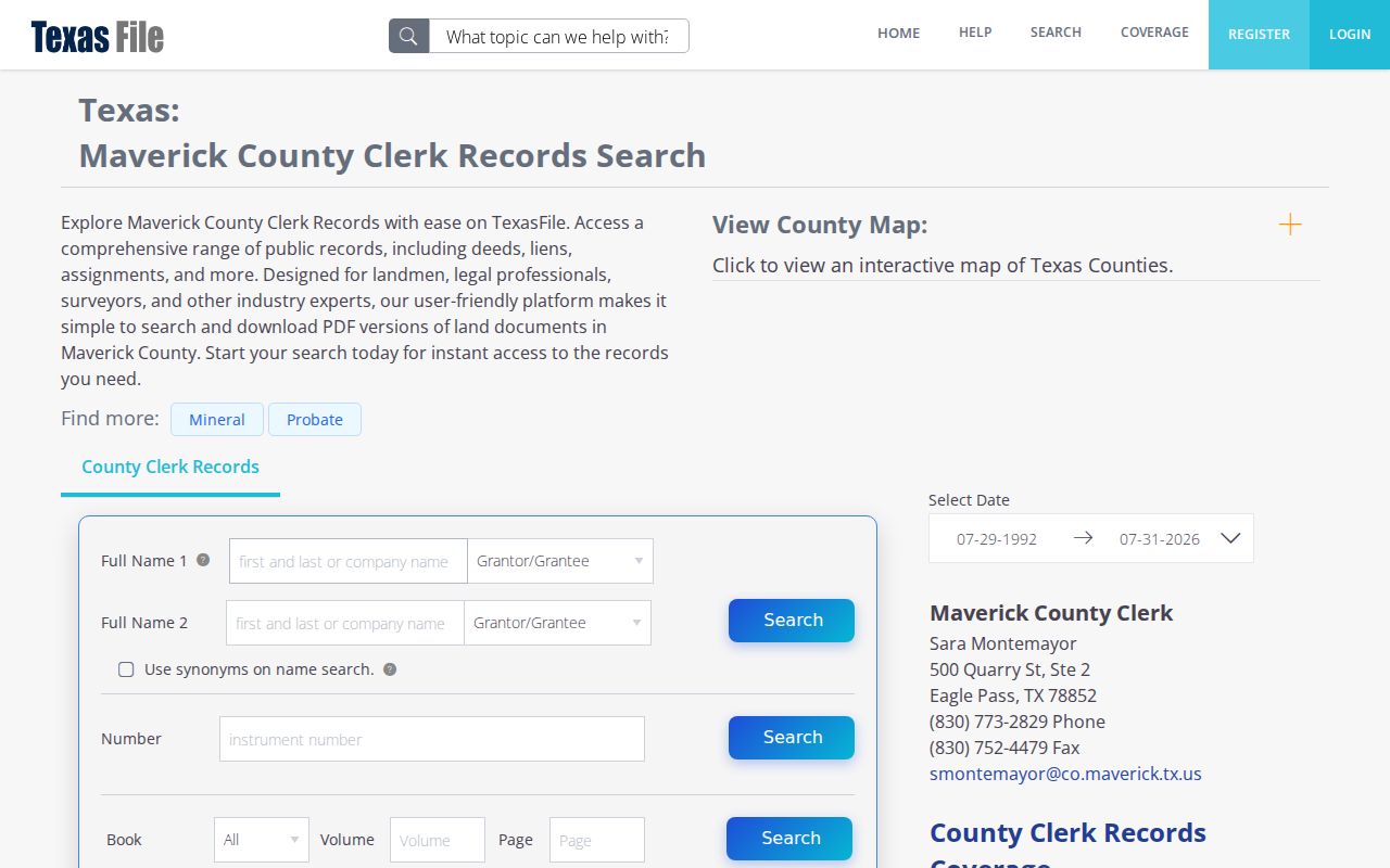
Its legal-description and date fields help connect an Eagle Pass street address to the recorded chain without assuming that an address alone appears in every instrument.
Use the latest grantee as the next name to investigate, then locate that party's earlier acquisition as the preceding link. A later deed may show a transfer of another parcel, but it does not establish where the seller lived. That restraint keeps an address-based record trail accurate.
Maverick Deed Index Years Matter
The online land index has a defined historical edge. TexasFile displays Maverick County's full index from July 29, 1992, while the Texas State Library's historical inventory identifies a deed-record index for 1871 to 1923 on reel 1016776 and deed books for 1871 to 1885 on reels 1016777 through 1016779. The online index is useful for modern transfers, but it is not a complete street history.
For an earlier Eagle Pass address, ask the Maverick County Clerk which book or index applies, and contact Texas A&M International University in Laredo or inquire with FamilySearch about access to the listed microfilm. Search by lot, block, tract, or subdivision where possible. Early Eagle Pass records can refer to the old crossing, Fort Duncan, California Camp, or the Twohig townsite, and no verified street-renumbering year should be invented to force a modern address backward.
Note: A recorded index reference is a lead, not a verified event, until the volume, page, reel, or image has been checked.
Compare Eagle Pass Address Records
This Eagle Pass address trail works best when its sources are kept separate, then compared. The table shows the usable address-keyed channels and the access route documented for each. It also identifies gaps. Neither a public searchable permit index nor a public address-query for code cases was located, so those records require a focused request rather than a promised online search.
| Address record | Custodian | What it can establish | Access channel |
|---|---|---|---|
| Appraisal parcel | Maverick CAD | Owner, situs, mailing address, IDs, legal description, values, and deed-history summary | Free web search; verify with CAD |
| Recorded deed or plat | Maverick County Clerk | Grantor, grantee, legal description, liens, easements, lot and block | TexasFile from 1992; clerk counter and historical microfilm for older material |
| Permit application or record | Eagle Pass Community Development | Job address, MCAD ID, owner or contractor, work description, and issuance details if retained | Narrow request or form; no public address index located |
| Code docket | Municipal Court and Code Enforcement | Docket date, violation wording, case reference, and address when a posted docket includes it | Docket PDFs or a city records request |
| Voter data | Maverick Elections and Texas SOS | Status and public fields subject to statutory protections | Individual portal or formal voter-file request |
IDs and legal descriptions tie the appraisal, permit, and deed records together. A street name helps collect a group of parcels, but it is less durable than the recorded property description. When a current name question replaces a street question, use the separate Eagle Pass resident lookup route rather than treating title records as a complete person record.
Request Eagle Pass Permit Records
The city residential permit application is an address-keyed record, not proof that a project was completed. Its fields include the job address, MCAD Property ID, legal description, owner and contractor details, work type, square footage, project cost, description, and office routing or issuance fields. For a specific Eagle Pass street, ask Community Development for the application and any retained issuance or inspection pages for a narrow address, MCAD-ID, and date range.
Code Enforcement is another separate channel. The office is listed at 1951 Taft Street, and municipal-court dockets are posted by date. No public address-keyed code-case search was located. A request under the Texas Public Information Act should state the exact street address, date range, and desired record type. Maverick County open-records requests can be sent through the county's public-information procedure at openrecords@co.maverick.tx.us, with a specific description and requester contact information.
Keep Eagle Pass Voter Data Limited
The Texas My Voter Portal is an individual status and polling-place tool, not a browse-by-street directory. Its documented routes use a VUID and date of birth, a Texas driver's-license number and date of birth, or first and last name with county, date of birth, and ZIP. The county Elections Administrator is at 501 E. Main Street, Suite B, Eagle Pass, and also serves as voter registrar.
A statewide voter file can be requested through Form 24-1 with county, precinct, mailing-address, and other permitted filters. The request requires a notarized noncommercial-use affidavit, a $75 deposit, full payment before release, and statutory handling. Protected residence addresses are excluded. Election Code rules also restrict advertising or promoting commercial products or services with requested list data. Ballot choices are never public.
Limits of an Eagle Pass Street Directory
Property records do not reliably identify non-owner occupants or all household members. Utility customer lists are private. Texas motor-vehicle personal information is restricted under the Driver's Privacy Protection Act and Texas Transportation Code chapter 730. Address-confidentiality and protected-voter rules can also suppress a residence address. A reverse or criss-cross directory may provide a historic lead, but no Eagle Pass-specific run or year range was verified in the research.
Lawful use. Use Eagle Pass address records for personal, lawful research such as property history, family history, civic transparency, or checking a possible scam. Do not use them to stalk, harass, threaten, or intimidate anyone. Texas Penal Code sections 42.07 and 42.072 address harassment and stalking.
When a record is unavailable online, the valid fallback is the custodian, not an assumption. The Maverick County Clerk at 500 Quarry Street, Suite 2, Eagle Pass, handles land records and can confirm current copy procedures. For older deeds, ask which original volume or microfilm reel supplies the missing period.